Contested Geographies in Taunton
Geographically, Taunton was poised to become both a site of military activity and of colonial expansion by the time of King Philip's War. Taunton was advantageously located near the crossroads of the paths leading to Plymouth, Boston, Swansey, and Montaup (Mt. Hope). Additionally, it lay just to the north of Assonet neck, a place that Plymouth men coveted deeply but had long been under Weetamoo's protection. Thus, it made sense that Taunton would be a place both heavily militarized by colonial troops, because of the mobility that was possible from the town center, and that it would be a particular target for indigenous warriors seeking to protect Assonet, as well as the path south into Montaup and Pocasset. As Schultz and Tougias note in King Philip's War, "At the outbreak of war ... Taunton (whose population comprised ninety-six families) became an active military center, serving as a gathering place for troops under Major Bradford in June 1675 and July 1676".[1] During the war, there were at least eight garrison houses in Taunton.[2]
As Schultz and Tougias observe, despite its key location, Taunton was only attacked twice during the war. The first was on June 27, 1675, when Native warriors attacked and burned the homes of John Tisdale, Sr. and his brother-in-law James Walker, both prominent men of Taunton; John Tisdale, Sr. was a casualty. A letter by Taunton settler John Freeman documented the incident and the death of John Tisdale, Sr., as well as the state of chaos in Taunton at the beginning of the war.
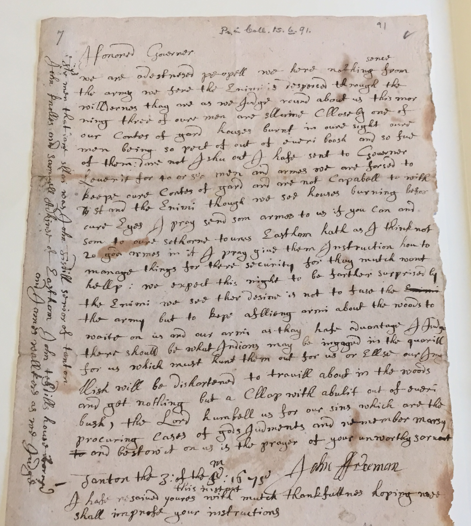
Honored Governor
We are a destressed peopell we have nothing sence from the army we find the enimie is despersed through the wildernes thay are as we judge round about us this mor-ning three of our men are slaine cllose by and of our corts[?] of gard houses burnt in oure sight oure men being so pact [picked] of out of everi boosh and so ful of them: Dare not Ishu [issue] out I hafe sent to Governor Leverit for 40 or 50 men and armes and am forced to keepe our corts[?] of gard and are not capabell to with stand the enimi though we see houses burning before oure eyes I pray send som armes to us if you can and som to our [sothorn] towns Eastham hath as I think not 20 good armes in it I pray give them instruction how to manage things for there security for thay mutch wont hellp: we expect this night to be further surprised by the enimi we see ther design is not to fase [face] the army but to kepe afflicting arms about the woods to waite on us and our armi as thay hafe advantage I judge there should be what Indians may be ingaged in the quorill for us which must hunt them out for us or ellse our Ingllish will be dishertened to travill about in the woods and get nothing but a [Cllap] with abulit [a bullet] out of everi bush, the Lord humbell us for our sins which are the procuring curses of gods Judgements and remember marsy to and bestow it on us is the prayer of your unworthy servant
John Freeman
Tanton the 3: of the 4th month 1675
I hafe rejoined youres with much thankfullness hoping wee shall impress your instructions
†The men that [...] was John Tisdill senior of Tanton John Knolles and Samuell Adkins of Eastham John Tisdills house burned and James Walkers as we judged.[3]
Tisdale and Walker held distinguished bureaucratic roles in Taunton: Tisdale served as Constable (1655, 1659), Selectman (1650, 1658, 1672-4), and Taunton’s Representative to the General Court (1674-5); Walker was on the original 1643 list of men to bear arms, appointed to Council of Taunton (which allocated arms and ammunition), and selected as Chairman of Taunton’s Council of War in 1671, 1667, 1675 and 1678. Walker’s position as Chairman to the “Councell of Warr” granted him authority over the town’s arms and ammunition.[4]
Tisdale and Walker were both involved in the attempted colonial expansion of Taunton. Walker had authored a letter to Philip on August 23, 1671 after he failed to relinquish his arms in Taunton and, earlier that year, he was appointed by the Court to “purchase the land of the Indians, in the behalfe of the towne of Taunton, lying on the west syde of the Taunton Riuer, from the Three Mile Riuer, downe to a place called the Store House.” Store House Point was located at the confluence of the Teticut (Taunton) and Assonet rivers, across the river from Weetamoo's carefully "guarded” planting and fishing grounds at Assonet.[5] Meanwhile, Tisdale's name appears on several land deeds that systematically encroached on Pocasset territory. Tisdale witnessed the notorious "mortgage" of Weetamoo's husband Wamsutta that resulted in the Freeman's purchase; he also appears as one of the grantees of the Freeman's deed. His "farm" was just north of Weetamoo's territory, on the east side of the Taunton River, above Assonet. As with the deeds at Dartmouth, the deeds around Taunton sought to expand colonial territory and threatened indigenous spaces, particularly the lands at Assonet.
Tisdall and Walker were also implicated in the militarized settlement of Sakonnet lands, prior to the war. "Tisdall's Farm" served as the mustering point for the 1671 gathering of about 100 troops from surrounding Plymouth settlements. During a meeting at the Council of War on which Walker served, plans were enacted for soldiers from surrounding Plymouth settlements to move against the Sakonnet saunkskwa Awashonks in a calculated maneuver to seize land by intimidation or violence. Under Major Josiah Winslow, troops from Taunton, Rehoboth, Bridgewater, and Swansey were to march to Sakonnet, via the Pocasset Path, to compel Awashonks’ people to relinquish their arms and force her submission. On August 8, 1671, troops were to meet “at or near Assonet, about John Tisdall’s farm,” and it nearly turned into an act of violence that would have likely sparked the war years earlier.[6]
Thus, the burning of “Tisdall['s] farm” and Walker’s home in June 1675 were not random but part of a longer history of conflict. Wampanoag warriors perhaps strategically targeted these spaces, which were not simply domestic spaces, but sites of military activity and colonial expansion. In particular, Tisdale's farm may have been a site of strategic importance to the warriors. Located in the southeast corner of Taunton, to the east of the river, Tisdale's farm was just north of Assonet neck and right next to the path leading south to Pocasset. Thus, it was an important site for the Native warriors to control early on in the war, as it was a point of access to Pocasset and Assonet for colonists coming from either Taunton or Plymouth.[7]
Taunton, then, was a highly contested space before and during the war. It served as one major crux within a larger struggle to control and protect lands. Weetamoo's presence near the town of Taunton becomes part of that story of fierce contestation, rather than a symbol of an inevitable outcome.