Corn-Mountains-Koasek-IMG-CL7.jpg
1 2017-09-03T19:35:33+00:00 Lisa Brooks fec693e828c406419bf2b9fc046e7ea8bc7558cb 6 1 plain 2017-09-03T19:35:33+00:00 Lisa Brooks fec693e828c406419bf2b9fc046e7ea8bc7558cbThis page is referenced by:
-
1
2017-08-17T14:00:18+00:00
Koasek
7
image_header
2017-09-03T19:44:04+00:00
Koasek is a significant homeland and wôlhanak, a fertile bowl that fed Abenaki families for millennia. Known as the “place of pines,” Koasek was not merely a single location (a dot on the map), but an entire region, the northern Kwinitekw Valley, where pines do indeed flourish. Of course, at this time, the pines must have been immense and impressive, growing hundreds of feet tall, providing a great canopy which sheltered many families. Koasek was also one of the many places on Kwinitekw that provided fertile ground for corn and her companions, considered the northern “intervales” of the river. At the junction of multiple trails, Koasek was an ideal center for inland communication and travel, with trails leading up from the lower Kwinitekw towns, west to Winoskik and Missisquoi, and east to Pemijoasik and Wiwninbesaki.
Koasek was one of several locations that Weetamoo and Quinnapin may have been traveling toward as they took the Kwinitekw trails that led north. Although English settlers were not familiar with Koasek, reports came down by June 1676 that many people had gone upriver, seeking sanctuary in Wabanaki towns beyond English reach. Governor Leverett reported that “the greatest number of the enemy are gone up towards the head of Connecticut River, where they have planted much corn on the interval lands and seated three forts very advantageously in respect of the difficulty of coming at them.” In referring to the “intervale lands” “towards” the Connecticut River headwaters, Leverett must have been speaking about Koasek, showing both his unfamiliarity with the Native geography and a newfound awareness of the northern country above the Connecticut River settlements. The Connecticut River continued to provide a sanctuary and a throughway for protectors, families and their captives during the many conflicts that followed. Even one hundred years later, during the American Revolution, Koasek was recognized as a gathering place for Abenaki families and for Native men who could be recruited to the new colonial resistance, against the English. [1]
[1] Salisbury, Sovereignty, 88. Schultz and Tougias, King Philip’s War, 282–3??? Noel Sainsbury ed., Calendar of State Papers, Colonial Series, America and West Indies, 1669-1674, preserved in the Public Record Office, (New York: Kraus Reprint Ltd., 1964), 406. Colin Calloway, The Western Abenakis of Vermont (Norman: University of Oklahoma Press, 1990). Evan Haefeli and Kevin Sweeney, Captors and Captives: The 1704 French and Indian Raid on Deerfield (Amherst, MA: University of Massachusetts Press, 2005), 129. Colin Calloway, “Sentinels of the Revolution: Bedel's New Hampshire Rangers and the Abenaki Indians on the Upper Connecticut,” Historical New Hampshire 45:4 (Winter 1990), 270-295.
-
1
2017-05-29T18:40:42+00:00
Benoni Stebbins' Account: "a forte a greate way up the River"
6
Contributed by Maggie King
plain
2019-06-03T14:41:36+00:00
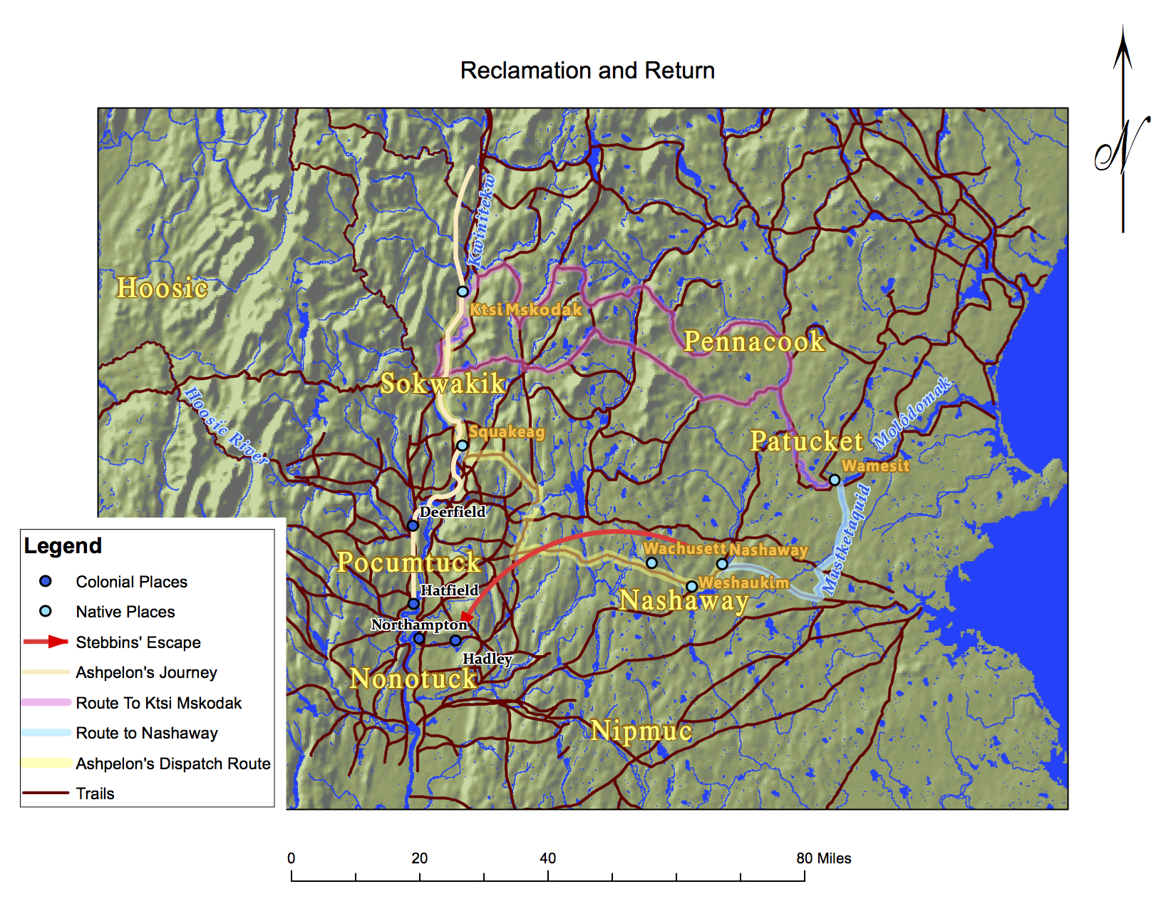
Sixteen days after Ashpelon’s raid, in a letter dated October 5, 1677, Major John Pynchon of Springfield requested assistance from Captain Sylvester Salisbury at Albany to solicit the aid of Mohawk sachems to intercept the party and return its English captives to safety.[1] His detailed account of the party’s whereabouts came from the account of captive Benoni Stebbins, who had been captured at Deerfield. Ashpelon’s party carried Stebbins with them upriver to Ktsi Mskodak, a fertile Sokoki intervale on the upper Kwinitekw, a refuge nearly unknown to English colonists. Stebbins was then taken with part of Ashpelon’s party, as the group split and headed east from Ktsi Mskodak to retrieve relations near Wachusett and Wamesit. Stebbins stole a horse somewhere near Nashaway, escaped and ran toward Hadley. Back in the colonial settlements, Stebbins relayed his story to the Northampton postmaster, Samuel Ells, who passed it on to Pynchon, a prominent local trader and military leader.[2]
As missionary Daniel Gookin later reported, at Wamesit, Wannalancet, a Penacook sachem, and “about fifty” of his people, being mostly “women and children,” were induced “either by force or persuasion” by “Indians that come from the French” to head north to Canada. The Indians that came for Wannalancet were “his kindred and relations” who told him that “the war” with the English “was not yet at an end,” that he would find “more safety among the French.” [3] Safer as it was for Indians in New France than in Puritan New England, inland spaces sometimes offered a better alternative to established, domesticated settlements—personal and political autonomy, game-filled hunting grounds, unmolested forests, and, above all, evasion from colonial oversight. In his letter Pynchon relayed to Salisbury that a “counsellor,” who came from “about Nashaway Ponds” (possibly referring to Wannalancet, en route from Wamesit, or one of the Nashaway/“Wachusett sachems”), “talkt of making a forte a greate way up the River & abiding there this winter.” [4] What would make the upper Kwinitekw an appealing place to seek refuge?
The counsellor could have been referring to either Ktsi Mskodak, where Ashpelon’s main party was encamped; Koasek, another Abenaki intervale further upriver, which had provided refuge to peoples during the summer of 1676; or the Kwinitekw headwaters, where Wannalancet and the Penacooks had spent the winter of 1675.[5] Koasek was an “advantageous strategic location” easily accessible to trails and waterways, French allies in Canada, mission villages at Odanak and the Sillery and “inhospitable” to English intrusion.[6] The central location of Koasek allowed for easy navigation to Canada and the Ktsitekw (St. Lawrence River), as well as many inland territories in Wabanaki. French missions and refugee hubs at Sorel, Schaghticoke, and even Koasek were not the only places that offered refuge to displaced Native peoples. There was constant movement through vast territory and into lands that were, up to this point, out of colonial purview.[1] “Letter from Major John Pynchon,” 53.[2] “Narrative of Benoni Stebbins,” 57.[3] Gookin, “Christian Indians”, 520-1.[4] “Letter from Major John Pynchon,” 54.[5] In June 1676, Governor Leverett reported that “the greatest number of the enemy are gone up towards the head of Connecticut River, where they have planted much corn on the interval lands and seated three forts very advantageously in respect of the difficulty of coming at them.” Noel Sainsbury ed., Calendar of State Papers, Colonial Series, America and West Indies, 1669-1674, preserved in the Public Record Office, (New York: Kraus Reprint Ltd., 1964), 406. Gookin, “Christian Indians,” 462.[6] Colin Calloway, Western Abenakis of Vermont, 1600-1800: War, Migration, and the Survival of an Indian People (Norman: University of Oklahoma Press, 1990), 85.