Our Beloved Kin: Remapping A New History of King Philip's WarMain MenuAbout the ProjectStart GuideNavigate Alongside the BookNavigate by PathAll MediaConnectionsContributorsTeacher ResourcesComing soon!Lisa Brooksfec693e828c406419bf2b9fc046e7ea8bc7558cbdeveloped in collaboration with irLhumanities
Bloody-Brook-Monument-IMG-PR5.jpg
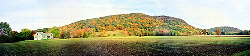
12021-03-10T14:58:21+00:00Marisa Parham0b3989f8b160e074aa2cff76ed0bc80e7e72fc1761This monument marks the site of the ambush of Captain Lathrop and his troop on September 18, 1675 at the foot of the Great Beaver, in South Deerfield, Massachusettsplain2021-03-10T14:58:21+00:00Marisa Parham0b3989f8b160e074aa2cff76ed0bc80e7e72fc17
This page is referenced by:
12021-03-10T14:58:12+00:00Connecticut River Valley, 16751image_header36202021-03-10T14:58:12+00:00Kwinitekw has long been an Indigenous superhighway, a crossroads of exchange, a canoe travel route, and a fertile bowl of flourishing agricultural towns. Even now, the Connecticut River Valley continues to draw Indigenous people from the region and far beyond and feeds many people from its intervales.
The outbreak of King Philip’s War in the Connecticut River Valley has long been associated with the ambushes of Captains Richard Beers and Thomas Lathrop, on August 26 and on September 3, 1675, the latter memorialized as “Bloody Brook” in colonial narratives and memorials. Although interest in the location of these ambushes persists, the Indigenous context of this place is often elided. These ambush sites were located in Pocumtuck territory, at the foot of the mountain known as Ktsi Amiskw, the Great Beaver. This prominent feature, rising above the river, has long held a story that conveys the consequences of greed and the potential, in the land and the people, for restoring balance in the social and ecological environment.
Follow the pages in this path to learn more about the outbreak of warfare in the Connecticut River Valley, the story of the Great Beaver, and the connection to James Printer’s imprisonment and release.